For decades, investing in real estate across developing markets has felt less like a strategic financial calculation and more like a game of roulette. The traditional land administration system characterized by dusty archives, manual surveying methods, and opaque title registries has long been a breeding ground for overlapping boundaries, fraudulent documents, and endless litigation.
Yet a quiet revolution is taking place beneath our feet. The introduction of Geographic Information Systems (GIS) is fundamentally reshaping the landscape of land administration, shifting power from paper-shufflers to digital coordinates. For institutional investors, diaspora buyers, and forward-thinking developers, understanding GIS is no longer merely a technical advantage it is an operational imperative for safeguarding capital.
1. Demystifying the Technology: What Is GIS?
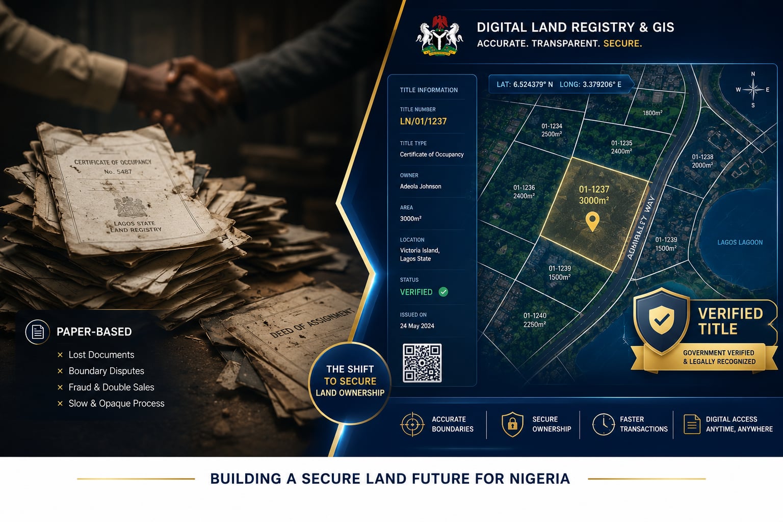
To appreciate its impact, one must look past the technical jargon. A Geographic Information System (GIS) is not merely a digital map or a collection of satellite images. It is an advanced, integrated framework that captures, stores, analyzes, and manages geographically referenced data.
In the context of real estate, GIS functions as the "Digital Twin" of land. It translates physical parcels of earth into precise, immutable mathematical polygons bounded by absolute GPS coordinates. By linking descriptive data ownership history, zoning classifications, tax status, encumbrances directly to specific spatial locations, GIS eliminates the ambiguity inherent in physical landmarks. Trees can be felled and survey pillars relocated, but a digital coordinate anchored to a global coordinate system remains unalterable.
2. The Fragmented Frontier: GIS Adoption Across the Federation
Because land administration is decentralized under prevailing legislative frameworks such as the Land Use Act, GIS adoption is not uniform; it is a fast-evolving patchwork across states. The market can be broadly categorized into three tiers:
The Established Pioneers
These jurisdictions recognized early that secure land tenure is the bedrock of economic expansion.
The Federal Capital Territory (FCT): Through the Abuja Geographic Information Systems (AGIS), the nation established its benchmark for digital land governance, streamlining title applications and spatial data management.
Lagos State: Driven by its integrated e-GIS portal, Lagos connects land registry searches with real-time digital mapping.
Edo State (EDOGIS) and Kaduna State (KADGIS): Both states have been widely lauded for aggressively digitizing backlogs of legacy paper titles, making the issuance of digital Certificates of Occupancy (C of O) remarkably efficient.
The Fast Followers
A rapidly growing middle tier including Ekiti, Ogun, Nasarawa (NAGIS), Oyo, and Kano is actively deploying aerial survey mapping projects, launching dedicated e-portals, and migrating archives to the cloud. This momentum is further accelerated by national initiatives like the Land4Growth programme, which aims to bring dozens of reform-ready states into standardized digital frameworks simultaneously.
The Legacy States
The remaining territories still rely heavily on manual paper charting within their Ministries of Lands. While GIS may be employed for basic urban planning, it has not yet been integrated into legal land registries, leaving transactions tethered to slower, analog workflows.
3. The Alpha Markets: The Case for Investing in GIS-Adopted States
For developers and investors deploying significant capital, targeting states with operational GIS frameworks offers unmatched strategic advantages:
Velocity of Capital: In a legacy state, performing a manual land search, verifying a root of title, and securing a C of O can consume months or years. In a GIS-driven state, registry searches and spatial verifications are often concluded within days, accelerating project lifecycles and reducing holding costs.
Enhanced Liquidity: Financial institutions treat uncertainty as an existential threat. Banks are demonstrably more willing to accept land titles as collateral when those titles can be instantly cross-referenced and validated through a secure state e-GIS database.
Zero Boundary Overlaps: Because the system mathematically prevents two properties from occupying the same digital space, developers face no risk of unknowingly encroaching on neighbouring plots or inadvertently building within government-acquired infrastructure corridors.
4. Walking a Minefield: The Risks of Legacy States
Investing heavily in states that have resisted or delayed GIS integration carries severe structural consequences:
The Menace of Double Allocation: Without a synchronized spatial database, a registry can easily issue two distinct titles for the same physical parcel. The resulting legal disputes can stall multi-million-naira developments for over a decade, trapping capital indefinitely.
Vulnerability to Sophisticated Fraud: Paper deeds can be forged, cloned, or backdated. In manual systems, verifying authenticity relies on human lookups through physical volumes a process highly susceptible to administrative error or deliberate manipulation.
Hidden Regulatory Exposure: An investor may purchase a well-situated tract of land, only to discover years later after construction has commenced that the parcel falls within a long-standing, uncharted government reserve. A GIS registry surfaces such constraints instantly, before a single naira changes hands.
5. The Currency of Trust: How GIS Transforms Real Estate Development
The most valuable asset in any real estate market is not brick, mortar, or location it is trust. Historically, transactions have suffered from extreme information asymmetry; sellers and agents held all the cards while buyers absorbed all the risk. GIS dismantles this imbalance by shifting trust away from individual personalities and into an objective, verifiable system.
A diaspora investor in London, New York, or Houston no longer needs to rely blindly on the assurances of an agent or family contact. By logging into a state's e-GIS portal, paying the prescribed fee, and entering coordinates, they can independently verify ownership, confirm exact dimensions, and establish whether a parcel is free from government encumbrances all without setting foot on Nigerian soil.
For developers, embedding GIS data into marketing and due diligence processes is a powerful credibility tool. Presenting prospective buyers with a certified GIS layout plan signals institutional transparency and immediately distinguishes a serious brand from speculative players.
6. The Horizon: PropTech, Smart Cities, and the Future of Land
The digitization of land registries is not the final destination it is the foundational layer upon which the future of smart cities will be built.
As GIS databases mature and integrate with technologies such as blockchain, the real estate market will evolve dramatically. Envision a world where clean, GIS-verified land titles are minted as secure digital tokens, with property transfers occurring near-instantaneously online and ownership histories updated automatically on an immutable ledger.
Beyond transactions, developers will transition from guessing market trends to deploying data-driven analytics with precision. By overlaying GIS land data with demographic shifts, infrastructure proximity, topography, and flood-risk modelling, builders can optimize project locations and minimize exposure long before groundbreaking.
The verdict is unambiguous: the future of real estate belongs to mapped, digitized spaces. States that proactively expand their GIS infrastructures will continue attracting the lion's share of local, diaspora, and international institutional investment. For the modern developer and investor, the mandate is clear follow the data, anchor capital in digital certainty, and build where titles are as absolute as the mathematics behind them.